Rothenburg on the Tauber
This entire site, images
and text, is copyright© MMV William Allin Storrer
|
(G1 S37)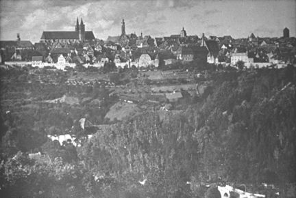
|
|
This is the city of Rotenburg-ob-der-Tauber. It is
situated on a limestone plateau 200 feet above the Tauber
River, in Bavaria. Its 11,000 inhabitants are mostly
Protestant, in this Catholic part of Germany. Note how the
city wall complements the natural barrier of the hill.
|
|
(G2 S36)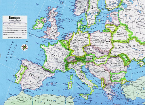
|
|
In present-day Europe, Rothenburg lies about forty miles
south of Würzburg and about fifty miles west of
Nürnberg by road. When the Holy Roman Empire held sway
over most of middle Europe, Rothenburg was near its center,
along or near some of the major trade and crusade routes.
|
|
(G3 S35)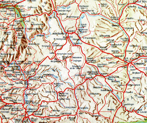
|
|
Today one may reach Rothenburg by bus, car or train from
major cities such as Würzburg, Nürnberg,
München and Stuttgart. It is the crossroads of both the
Romantic Road through Bavaria and the Road of Castles
through mid-Germany.
|
(G4 S35-2)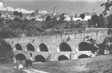
|
|
(G5 S34)
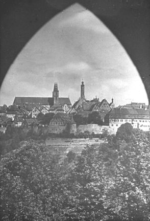
From our vantage point in the shadow of the Kalkturn, we
look north over the south valley to the old city. This land
was settled by counts of Rothenburg in 786. In 1172 Frederic
I of Hohenstaufen granted civic rights to Rothenburg.
Rudolph I of Habsburg gave Rothenburg the privileges of a
Free Town of the Empire, subject only to the Emperor, in
1274, and it remainded under this grant until 1802
|
|
(G6 S33)
|
|
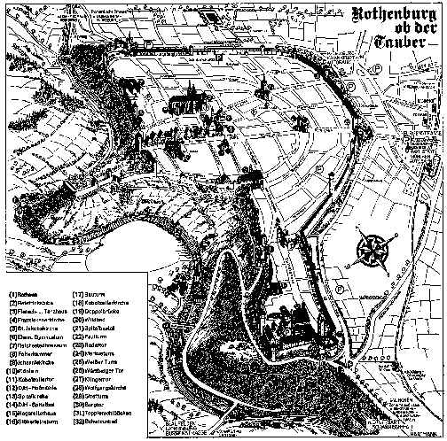
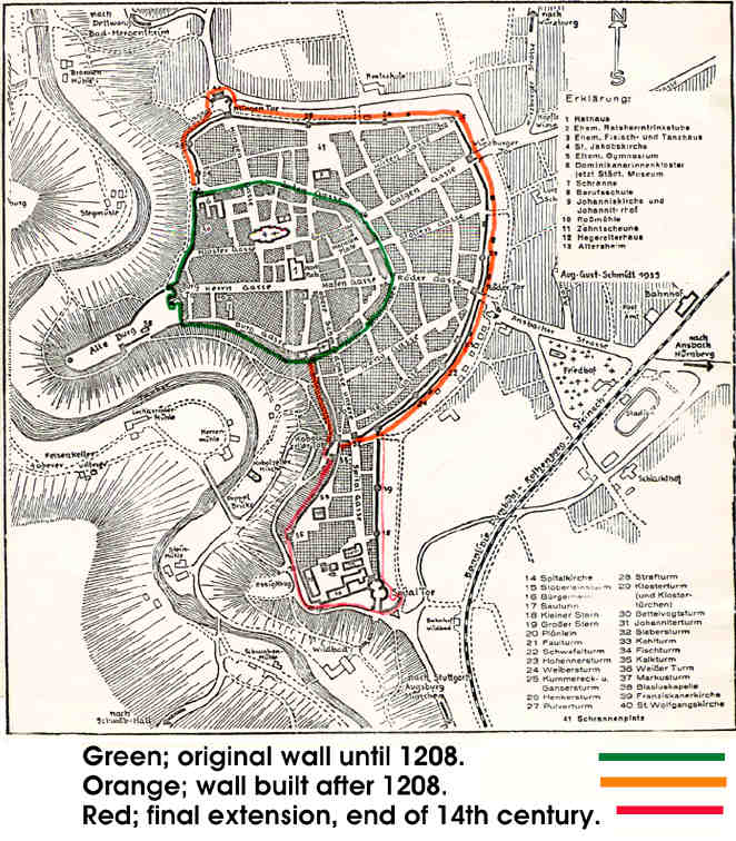
Here is a map of Rothenburg. The Tauber runs through the
heart of the valley, and the 200 foot cliff provides a
natural barrier to the enemy. On the west-most promontory
once stood a castle, with one gate leading to the plateau.
That gate now looks West, for the town has displaced the
castle. Note how the inner (old) town, which seems to
imitate a fan in shape, spreads from this old gate. The
first wall made use of the natural barrier wherever
possible; the fan-shaped space required the least amount of
moat for the greatest amount of city space.
In the center of the old city we find the town hall, market
place, and principal church. Note how the streets radiate to
the main gates. If we investigate the size of each city
block, we cannot fail to notice that each allowed for ample
inner court space for the gardens that supplied fresh
vegetables to the city tenants. And central to the plan are
the church and the town hall.
The town expanded beyond the limits of this first wall in
1208, by filling in the old moat, and building another wall
and moat further out. Still, the natural barrier of the hill
was used as much as was possible.
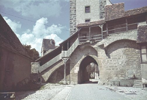
Two centuries later another addition was made to the south.
The hill formed half the perimeter of this acquisition.
We will enter Rothenburg by climbing this hill to the
Kobolzeller gate. Note that this entrance is a double gate
up the hill, with a tower gate at the top of the hill. This
was necessitated by its position on the boundary between the
natural barrier of the hill and the constructed barrier of
the moat. This is the only direct entrance from the valley.
|
|
|
(G7 S32)
We are standing just inside the first gate at the
Kobolzellertor. Note the holes in the second gate. If as an
enemy, we got this far in our attack, the citizens could
still pour hot pitch, boiling water, or whatever they chose
over us through these holes as we tried to pass through the
second gate .
|
|
(G8 S31)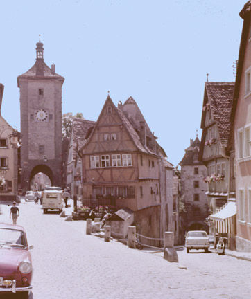
|
Our entrance to Rothenburg is down to the right. The
Siebersturm is on the left; once the southern entrance at
the top of the hill, it now leads to the most recent
addition to Rothenburg (circa 1400). This city square is
called the Plönlein, part of "Smith Street" which runs
from the City Hall to the Siebersturn. The covered trough,
center, was once filled with water as well as trout freshly
caught out of the Tauber and nearby lakes. The trout were
probably brought up the hill through the Kobolzeller gate,
and left alive in the trough until sold on market day. Note
also the house on the right (in the graphic) and how each
floor above the other extends further over the street; the
structural solution to the building of upper floors is
demonstrated in this house. The house directly in front of
us shows somewhat typical domestic construction, with the
timbered structural supports clearly outlined by the filler
material of the walls
|
|

|
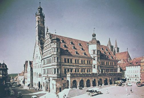
(G9 S30)
If we walk up Smith Street we come to the Rathaus, which
is just across the main city square from where we now stand.
The left section with tower dates from 1240/1250. The right
section was begun 1572 (after fire damage on Ascension
Sunday, 1501, had largely destroyed it),and the porch dates
from 1681. The tower is 165 feet high, and is supported on
the roof only, with no structural support reaching directly
to the ground, This was quite a unique engineering feat in
its day. The second floor of the main; building served as
meeting place for the city officials.
|
|
|
|
(G10 S29)................Here we have a view of the
newer building with its Baroque period porch.
|
|
|
(G11 S28)
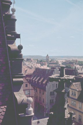
Part the way up the tower, we may pause to look east over
the town, and to note the sculpture on the town hall dating
from 1572, as well as the lightning rods of a more recent
era. Note the steep roof of the building in the center
mid-ground; so steep as to assure that no snow would cling
to the roof. (Snow is quite heavy, and the roof was often
doing well to hold its own weight.)
|
|
|
|
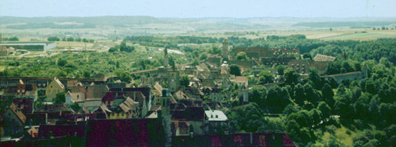
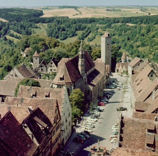
One hundred sixty-five feet up we look south. We can see
the South city (the last walled addition to Rothenburg) as
well as some post-war industry beyond its walls, the
Siebersturm and Kobolzellertor where we entered the city.
Note the south edge of the old town in the foreground, and
the broad plain to the south. ......(G12 S27)
|
|
(G13 S26)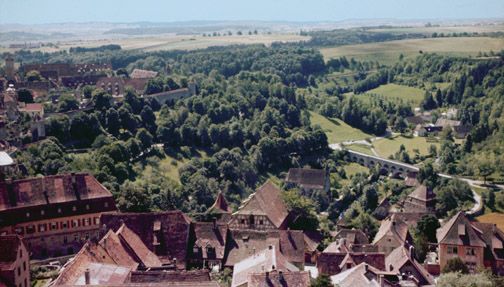
|
|
Further to the west we view the Tauber Valley, the
Doppelbrücke built in 1330 to span the Tauber, and the
Kobolzeller Kirche, the first permanent church built outside
Rothenburg's walls (1472). If we look closely, we can see
signs of trees and other foliage in the yards of the main
city blocks in the oldest part of town.
|
|
(G14 S26-2)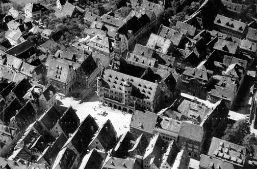
|
|
Aerial view of the City Hall and its tower, showing the
inner court yards (upper left & upper right corner, the
city square and market shops (upper left of city square),
Smith Street leading to the left, Herrngasse (leading
diagonally from left center to up right), and the apse end
of St. Jakobskirche (far right, lower).
|
(G15 S25)
|
|
|
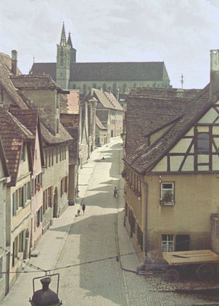
Now we are looking due west down the widest street of the
city, the Herrngasse, which once served as the main street.
This street was once tree covered, but pressures of modern
society have caused the removal of the once beautiful
providers of shade. Their replacements, located further to
the side of the roadway so that the inevitable auto may
invade the city sanctuary, have had but little time to grow
back to the point of providing shelter.
The Burgtor (1280) marks the western limit of the city; the
castle of the Hohenstaufen was in the wooded promontory
beyond, but was destroyed in 1356 and 1425.
On the left side of Herrngasse is the Gothic church of the
Franciscan brotherhood (1281, consecrated in 1265[?]). There
was a nunnery two blocks to the north.
"In 1258, Luitpold of Nordenberg appears as donor of the
nunnery and asylum for the daughters and widows of the
Franconian nobility. These nuns were not obliged to make a
vow, and were allowed to marry . . . No wonder life of the
noble nuns was very worldly until 1400, when Burgmeister
Toppler ordered new rules and decided that common women also
could become members of the Dominican nunnery."
The interesting point in this bit of history is that which
we may note concerning the Reformation, which we commonly
think of as having been started over such questions as who
should control the local churches and church practice, yet
here in the Rothenburg of 1400 we find the Burgmeister
running things pretty much at his discretion. Perhaps it is
no small wonder that Rothenburg was a center of
Protestantism in that part of Germany which remained largely
Catholic.
|
|
|
|
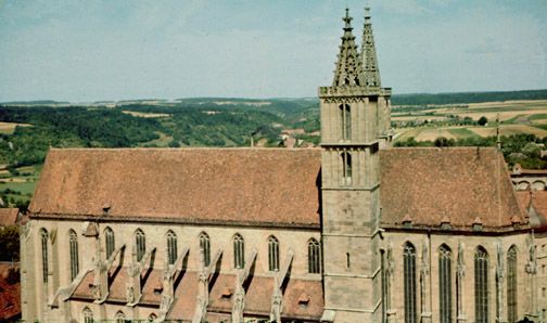
To the north, our entire view is taken up by St.
Jakobskirche, a Gothic edifice of 1373. The spires date
1311-1471. Notice the buttressing over the side aisles, and
the two towers topped each by a flèche of pierced
stone. This pierced stone type sculpture was common at this
time. Note also that this church is not of the cruciform
plan, the aisles being quite the widest part of the
structure. There is a striking similarity here to the
basilica plan in use in Italy.
|
|
(G18 S22)
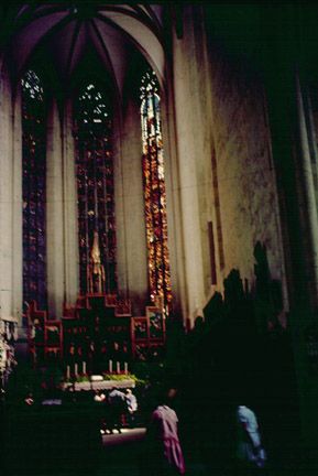
We are now inside St. Jakobskirche, looking east to the
altar. This church houses the Altar of the Holy Blood
(1501-05), a wood-carved depiction of the Last Supper, by
the German Renaissance sculptor, Tilman Riemenschnieder.
This church was looked upon as the last refuge and source of
freedom for the convicted criminal. Criminals were given a
last chance to prove their innocence in a chase where they
were the hunted, the constabulary)ulary the hunter. If the
criminal outran his pursuers to the altar, he was considered
innocent and given safe passage beyond the city gates.
|
|
|
|
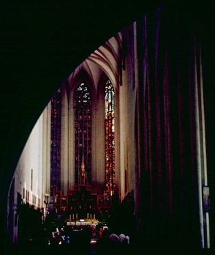
(G19 S21)
Here is a closer view of the apse. The stained glass
windows date from 1350. The Altar of the Twelve Apostles
dates from 1466, and was painted by Friedrich Herlin.
|
|
(G20 S20)
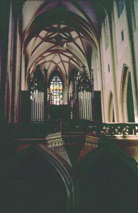
This is the west end of the church, with choir over both
the narthex and a tunnel vault over the Klingengasse. Here
the Gothic arching is clearly revealed; note the arch of the
windows and the vaulting, as well as the stained glass.
|
|
|
|
(G21 S19)
Looking north from St. Jakobskirche, we see the
Klingentor, the northernmost gate to the city, built in
1395. Water was pumped almost three hundred feet from the
valley to the top of this tower, and was distrubuted to at
least two of the city's fountains from here. Of course, when
a city was besieged, its most vulnerable point was its water
supply, which almost always lay beyond the city walls, and
was consequently subject to poisoning. To avoid such
dangers, Rothenburg devised, in the twelfth century, a
system of water pipes that reached far out to springs in the
country-side. Only the Burgmeister, and city water
commissioner knew where these lines lay, and it was treason
to divulge the secret. Rothenburg survived many a long siege
because of this wise precaution.
Note the length of the city block. Behind these houses was
the important inner courtyard whose flower and vegetable
gardens brought the country inside the city walls.
|
|
|
|
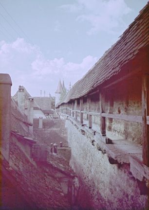
The wall along the valley ridge needed comparatively
little in the way of defense; the cliff was a formidable
challenge to any army. But the wall to the north, east and
south was vulnerable. Here there was a thick wall with no
moat outside, and inside there was an upper covered walkway
along which the burghers could reach their battle stations.
The Klingentor marked the last entrance to the city on the
north before the moat ended at the cliff a short distance to
the west. Thus it was a main point of entry to the wall
walkway, which we see in this view. .....(G22 S18)
|
|
|
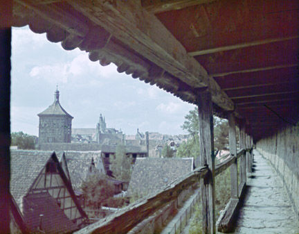
From the wall walkway we gain a fine view south down the
Klingengasse to St Jakobskirche. This also gives us a good
view of the length of the city block. In graphics G37 and
G38 we shall take a closer look at the walkway of the wall.
(G23 S17)
|
(G24 S17-2)
|
If for a minute we walk east of the Klingentor, we may
take note of an interesting element of construction; this is
a combination of buttress and arch into a buttressed arcade.
(G25 S16)
|
|
|
|
(G26 S15)
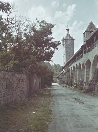
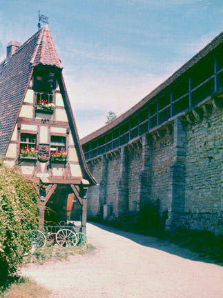
Let us continue west and south along the wall of
Rothenburg. We have already noted the function of one tower.
The Klingentor served as water tower. The Faulturm, the
tallest of Rothenburg's towers, stored grain for fertilizer.
Our view now is of the Strafturm, a tower feared bakers who
tried to shortchange their customers. When a loaf of bread
failed to weigh in at the minimum standard, the baker was
taken with his underweight loaf to this tower and lowered
outside into the moat. Baker and loaf of bread soaked up
water, enough water to make the loaf weigh the minimal
standard. Only when the loaf reached the proper weight could
the baker be released from further dunkings.
|
|
|
|
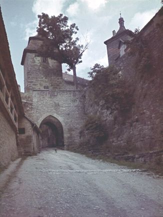
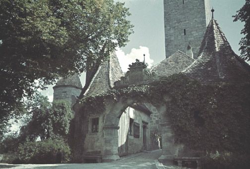
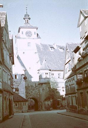
This is the westernmost entrance to Rothenburg, yet not
really an entrance; it is the exit from the former castle
grounds. Because of the steep cliffs leading to this area,
the gate rarely had to face any major armed siege. The gates
date from 1591/96, the tower from 1280. ...(G27 S14)
|
|
|
|
(G28 S13)
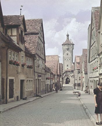
If we walk through the Burgate and up Herrngasse, we
eventually find ourselves back at the Town Hall. Turning
around and looking back, by means of this view of
pre-tree-replanting-vintage, we are able to view Herrngasse
as it once was, fully tree-covered. We also note a strange
object in the middle of the road.
As we noted earlier in this presentation, the Klingentor
served as a water tower. but where was the water
distributed? Certainly not directly into private homes, as
the cost would have been prohibitive even for the richest
merchant. This little garden and others similar to it, with
or without statues, were in the past history of Rothenburg
the central water fountains. The townspeople gathered 'round
to get water and spread the latest gossip and news. But the
town has since modernized, and plumbing goes directly into
the houses; the consequent demise of the fountain is a
serious loss to the picturesqueness of Rothenburg.
|
|
|
(G29 S12)
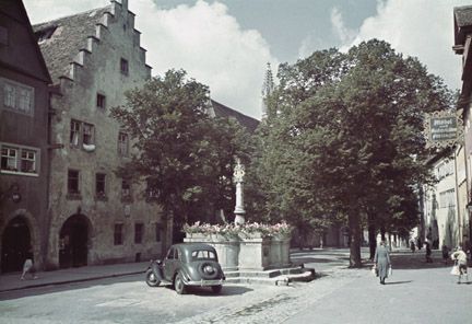
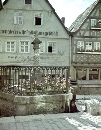
Here we have a view of another fountain. It is located in
the middle of the street. If we note how the blocks Of the
street surface are built up around the fountain, we may be
able to imagine how the street was long ago when dirt, not
stone, was all there was.
We must also take note of the building on the right. The
troughs in front might be storage bins for fresh vegetables,
or for fish as was the trough in the Plönlein. The
glass windows behind are, of course, a seventeenth century
or more recent addition. In the medieval era this was an
open covered walkway, with open "windows" viewing into the
front-room shops. If we look carefully, we can see how the
left building was constructed with an arcade for a similar
purpose. In the right building we may also take note of the
timbered framework structural plan.
|
|
(G30 S11) 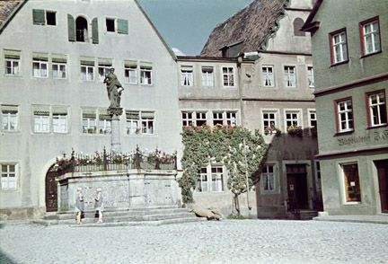
|
|
In another city square, we see an old fountain built
after the thoroughfare was paved.
|
|
(G31 S10)
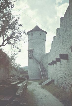
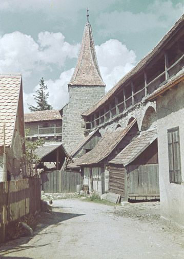
We are now in the northeast corner of town. Here we see
the dirt walkway, old wood structures for housing animals
and tools, and part of the wall and its walkway, as well as
the low tower. This tower (probably the Kummereck-u.
Gansersturm), like the Strafturm, was not a gate tower, but
only a part of the town's fortification. Our view is of the
inside of the wall that was built around the outer city
after 1203.
|
|
|
|
(G32 S9)
Proceding a short ways south, and then turning west up
the Galgen gasse, we come to the Weisserturm, one of the old
tower gates to the old city. There once was a moat this side
of the tower, but it was filled when the town was extended.
The Weisserturm itself dates from 1204. The timber framed
building with oriel is the former "Judentanzhaus."
|
|
If one follows the old wall south two blocks, then steps
east a short way, he has this view of another of the old
tower gates, the Markusturm (1204), once the eastern-most
entrance to the original Rothenburg. We may also notice (in
the image) another former public fountain.
(G33 S8)
|

|
|
|
(G34 S7)
Southeast of the Markusturm, along the outer wall, we
come to what may be the best preserved piece of domestic
architecture typical of what one would have found in the
medieval town of Rothenburg. This is an old shop: now
a.bicycle repair shop, it once was used for repairing wagon
wheels. The street in front is typical, having never been
paved over. The overhanging upper floors protect the open
shop on the main floor. When glass became cheap, or the
tenant rich, many burghers built out the lower floor and
closed in the shop with glass windows, but this house still
preserves the medieval character, seemingly unaware of many
modern conveniences. We must note how small the upper
windows are: to keep out the cold air of winter. They were
not enlarged when glass became available cheaply. Note also
the timber structure showing through the entire facade. The
roof slopes steeply to prevent snow from clinging thereto.
|
|
We may now pass into the southern extension to the limits
of Rothenburg, and though most of the structures here date
from a time considerably past the medieval, they are worth
our note as part of the total picture of Rothenburg; as it
grew from medieval town to Renaissance city, a Renaissance
city that never really grew, for Nürnberg. and
Würzburg were better located on rivers and surface
trade routes.
Our view is of the Hegereiterhaus, built in 1591 by the
architect Leonard l,Weidmann of Rothenburg. This is where
the supervisor of the hospital grounds lived.
|
(G35 S6)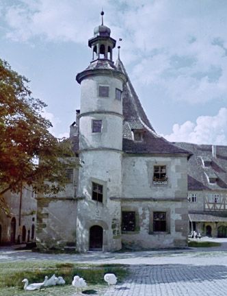
|
|
(G36 S5)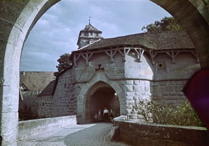
|
|
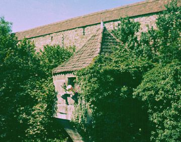
The southern extension with its hospital was not
incorporated within a city wall until the end of the
fourteenth century. Here we are viewing; the main southern
gate, the Spitalbastei , a double-walled and moated entrance
dating from 1572. The Spitaltor rises in the background.
|
|
|
(G37 S4)
Now let us look at the wall that faces the open plain.
Here is where the town is most vulnerable, as the army can
attack from the level of the wall. But they must cross the
moat first, then scale the wall. Here we have a view of the
inside of the south wall at the walkway which the defenders
used to reach their battle stations inside the thickness of
the wall. The roof, we must note, is of inflamable
materials.
|
|
G38 S3)
When we step onto this walkway, we note the value of the
roof. It gives needed protection from fire arrows and stones
that might be shot or slung over the wall. And if the
besiegers made it up the wall, they had no easy way to drop
onto the walkway. As they came down from the roof, the
defenders could kill them off one by one. Maybe from this we
may more fully realize how much the wall meant to the
medieval man, and how it represents his particular state of
mind.
|
|
|
|
(G39 S2)
Outside this wall, between the Rödertor (1280) and
Rödergate, the inner and outer main gates respectively
of modern Rothenburg, we may pause to look into the old
moat, now overgrown with scrubbery and trees. The slits in
the wall allowed the burghers to shoot at their adversaries,
yet they presented a difficult target for all but the
sharpest of shooters among the besiegers. This building that
juts out from the wall allowed the defenders a more direct
position from which to ward off invaders.
|
|
(G40 S1)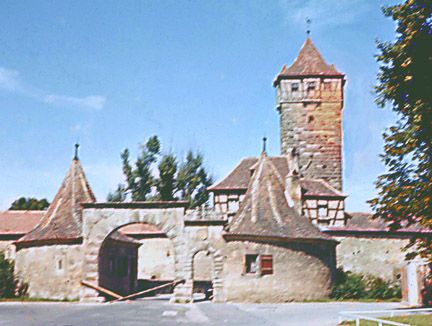
|
|
We leave Rothenburg by the Rödergate, added in 1615.
a time when the bridge over the moat was no longer raised
for protection. For visitors to present-day Rothenburg, the
Rödergate, and Rödentor (1280) beyond it, serve as
the entrance to the medieval past, a past preserved as part
of the tradition of a town that never gained the trade that
was necessary to command its modernization.
|
|
T H E M E D I E V A L C I T Y
Medieval man's "conception of the world hardly differed
from that of Aristotle . . . the earth was the center of the
universe . . . Medieval man was faced with perplexities
which threatened to undermine the unity of his religious
faith with his practical life . . . These disruptive forces
drove him into fraternal association with his fellow
citizens . . . He needed the visible limitation of his
community by a wall, which was above all the expression of
this mental attitude . . . He needed the Church, but he
placed beside it administrative buildings, the town hall and
the guild halls." [Gutkind, E. A. The Twilight of Cities.
New York: The Macmillan Co. (The Free Press of Glencoe),
1962. 24.]
Let us concern ourselves with medieval man. We shall not
consider all the vicissitudes of medieval man's life, nor
will we explore all the elements of' his society in the
depth necessary to a true foundation of understanding from
which we may learn. to think as he did. We will, however,
turn our attention to the principal problem that medieval
man had to conquer in his lifetime. Let us specifically
consider that entity through which, perhaps, medieval man
best expressed himself, the medieval walled city; the
collective medieval man's self.
Why, when we think of medieval cities, do we always think
first of walls? What was this wall that our minds in the
Twentieth Century so quickly recall as the identifying
characteristic of the medieval city?
The wall, with or without a moat, defines and symbolizes the
medieval city, for it made that city an island. This has
both physical and psychological implications. The wall
provided a means of defense against ones enemies. And those
who lived within the wall belonged, those who lived without
did not belong. Five centuries of violence preceded the
founding of the medieval city, and caused its growth. Early
medieval man lived with the constant fear that his next
breath might be his last. His greatest desire was for a
place to rest without fear.(l4)[The number in parentheses
refers to the page in Lewis Mumford's The Culture of Cities
from which the author of this presentation draws support for
the particular contentions preceding the reference. See the
Bibliography and, for full quotes of each of these
references, AppendixA.] He learned quickly that a wall that
protected his neighbors and their overlord could also
protect himself from usurpation by that overlord.(15-16) The
wall thus became a weapon by which medieval man gained
independence from his feudal overlord.
But this independence was gained only at the expense of a
new kind of dependence, a dependence based on association
with others of his kind. There was no security except in
association, for one could hardly build a wall around
oneself only and defend it against all comers. Medieval man
sought membership in groups.(29)
There were three groups to which medieval man most needed to
associate him self: the church, the guild, and the city.
When the Roman Empire fell, only the catholic church
survived. and in the very act of survival, and in its
continuing existence, the church represented the surest
element of continuity in medieval man's short life. The
church was truly, at that time, the catholic, the universal,
institution. It was a source of well-being to all its
members; to be cut off from its communion was a punishment
feared even by kings. The church in this period of was not
what it is today. It served then as community center, or,
from a campus oriented viewpoint, as a student union.(55)
The city's money might be stored there, as well as its arms.
Banquets could be held within, and plays. The pews of today
were not there in the medieval: ages. The floor was bare.
The church was truly a multipurpose building.
"Under the guidance of the church, elective affinity took
the place of consanguineous relationship." Family ties,
though important, gave way to the ties of mutual economic
needs and productive skills, causing children, as shall be
noted in more detail later, to leave their parents and live
with other families. Next to the church, the guilds were the
most important. Association of medieval man's life. There
was no such thing as universal education. The guild set the
standards of workmanship in their respective trades. The
guilds also controlled the number of persons practicing a
given trade. Admission to apprenticeship in a guild usually
guaranteed the apprentice a certain and well-defined
standard of economic well-being for the remainder of his
life. The choice, most often made by his parents, of the
right guild could be the most important choice in a man's
life, and apprenticeship to the right, master, be he painter
or baker, carpenter or fuller, could determine a man's
destiny.
It should also be noted that the modern university was born
in the medieval ages as an outgrowth of a guild-like
organization for the preservation of knowledge of a
non-craft nature. The university was the first or
organization, outside the cloistered mind of the church, to
preserve knowledge and disseminate it to future generations
down to the present time.
Medieval man also belonged to a city. What did he gain by
this membership? He gained freedom from feudal dues.(32) If
he lived in the city a year and a day, he was freed of the
obligations of serfdom.(25) But this freedom, as we must see
in all aspects of medieval life, was not without its
obligations. There was military service or for 11 but the
officers of the church. The duties of the night watch and
the guard of the city gates was assigned: to all on a simple
basis of rotation.(32) In this we may see a more advanced
state of democracy than exists, perhaps, in our own age of
paid mercenaries, and maybe our modern streets would be void
of crime at night if every citizen had to take his turn in
patrolling them.
The essential module of the medieval urban city was a family
unit that included as a part of the normal household blood
relatives, a group of industrial workers, and domestics.
These latter two groups lived as secondary members of the
family, but nonetheless members.(35) They worked together,
ate together, and, yes, literally slept together in the
second floor dormitory. Privacy, as we know it today, was
then unknown.(39)
Let us pause for a moment on this latter aspect of medieval
life. Mumford states quite poetically; "Privacy in bed
preceded the private bedroom."(41) Until curtained beds were
thought of, sexual activities within the house must have
been enjoyed only under cover and in the dark.(41) No wonder
that engravings and woodcuts that come down to us today show
the handsome lad making merry in the hay, or going off into
the woods with his lass. The countryside offered privacy
unknown in the corporate society of the city.
What was the basic structure of the house, and its
implications? The front of the house faced onto a street;
its front room was the shop, and since it was not
glass-enclosed on a general basis until the seventeenth
century,(56) the overhang of the second floor, where it
existed, provided much-needed protection from the weather.
This overhang was, of course a structural solution to the
supporting of the upper storeys.
|
|
|

|
The shop was connected by an open gallery to the
kitchen in the rear, and there was a garden beyond
that. The living rooms and beds were usually
upstairs.(39)
|
|
|
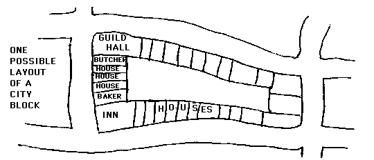
As we may now note, houses were usually narrow, but deep.
Land was at a premium, so houses rarely stood free, but made
use of all available ground space by butting wall against
wall, so that several houses formed a row, and three, four
or more rows formed a block around the gardens which were a
major element of an inner courtyard.(38)
|
|
|
There was usually a gate, in one of the rows, leading to the inner
courtyard.
Building the houses in this manner helped protect all the houses
against the elements. Abutting walls helped prevent loss of heat. But
however much a city this was, its character was never far removed
from the country, As long as the gardens remained in the courtyard,
the medieval city was a healthy place to live. Only after the
medieval era were many of these courtyards built over, and only then
did overcrowding become a problem.(44)
Municipal government was a relatively new idea at this time . . . In
feudal times the people owed their allegiance to their overlord, but
hardly did he owe them anything. But as much as the burgher served
his city as policeman and soldier, so the city provided him services.
The municipal government directed the collective functions of the
city. The brook that supplied the water had to be guarded and public
fountains had to be built in the public squares.(48)
And if we note that private homes might lack an oven for baking,
there was a public one at the bakers.(41) Though it might have lacked
a bathroom, there were public bath houses, and bathing was so popular
that the idea even spread back out to the countryside.(47) There were
hospitals in most every town.(49)
The shape and size of a medieval town were determined largely by two
factors: the wall which was its physical limit, and the open central
yard in or around which were located the principal church, the town
hall, and usually guild halls, the market and the inns.(59) A typical
walled city ranged from 400 to 40,000 (this latter the size of London
in the fourteenth century),(59) and when a city was filled a new city
would be built elsewhere. Only occasionally was the wall extended.
Many cities never grew beyond a few hundred inhabitants, for they
failed to attract the commerce so necessary to their survival,
growth, and expansion.
In the medieval ages, the street was less a means of transportation
than a line of communication.(55) The main streets were planned to
facilitate movement of men and arms to the main gates.(54) Lesser
streets might twist and turn all which ways, but such a plan broke
the chilly winter wind that leapt the wall between city and
country.(56)
Whatever else we may think of the medieval town, we must not think of
it unsanitary. "Crude sanitation is not necessarily bad sanitation,"
states Mumford.(44) The cities were not overcrowded and were usually
very clean. Though animals roamed free, they helped clean the town.
The pig that roved the street was the world's first automatic garbage
disposal and perhaps the best member of the Board of Health. When we
hear of epidemics, we should not be too hasty in thinking that they
were caused by a lack of sanitation, but perhaps by lack of a good
winter diet. Francis Bacon. died when his first experiment in cold
food storage failed - on himself.
This, then, is the medieval city, a curious blend of town and country
walled in by tightly knit associations of church and guild, family
and municipality, and stone and water, an island unto itself;
medieval man's collective architectural expression.
APPENDIX A
Lewis Mumford. The Culture of Cities. New York: Harcourt, Brace and
World, Inc., 1938.
Following are quotes from the above source, as indicated and
identified by the page number in parentheses.
Five centuries of violence [up to the 11th century], paralysis and
uncertainty had created in the European heart a profound desire for
security . . . when every moment might be ones last moment, the need
for protection rose above every other concern, and to find a safe
haven was about the most one asked from life.(14)
Sheer necessity led to the rediscovery of an important fact . . . the
strength and security of a fortified stronghold . . . could be
secured even for the relatively helpless people of the lowland
provided they built a wooden palisade or a stone wall around the
village.(15) This discovery, fortunately, proved to be double-edged.
If the wall could protect the town from outside invasions more
successfully than the feudal war-band, could it not also protect the
community from the invasions and usurpations of these greedy and
arrogant 'proctectors'?(16)
The revival of trade in the eleventh century, then, was not the
critical fact that laid the foundation of the new medieval type of
city . . . Commercial zeal . . . was a mark of the new sense of
security that the walled town itself had most potently helped to
bring into existence.(l8)
The city charter was a social contract; the free city had legal as
well as military security, and to live in the corporate town for a
year and a day removed the obligations of serfdom.(24-25)
The free city was a new source of wealth, but the challenging
self-confidence and independence of the people who rallied to the
Commune was a threat to the entire feudal scheme.(27)
In Western Europe, after the fall of the Roman Empire, the one
powerful and universal institution was the Church. Membership in that
association was a constant source of life and well-being, and to be
cut off from its communion was so great a punishment that, until the
sixteenth century, even kings trembled before it.(27)
In the early Middle Ages, even business and religion were in organic
relationship . . . But at the end of the Middle Ages even pious
matters have a worldly tinge: one seeks security no longer in the
depths of the Church, but in a shrewd loan, backed by a note, and
ultimately vouched for by the armed might of the state. Faith gives
way to 'credit.'(28)
The unattached person during the Middle Ages was one either condemned
to exile or doomed to die: if alive, he immediately sought to attach
himself, at least to a band of robbers. To exist, one had to belong
to an association . . . there was no security except in association,
and no freedom that did not recognize the obligations of a corporate
life.(29)
Outside the church, the most universal representative of corporate
life was the guild.(29)
. . . the guild rises and falls with the medieval city: the guilds
are the city in its economic aspect, and the city is the guilds in
their social and political aspect.(31)
The center of the municipalities activities was the town
hall.(31)
By membership in the municipality one escaped feudal dues: one
assumed burgher responsibilities. Not merely was military service
imposed on males who were not officers of the church, but the police
force of the town was selected by rotation from among the burghers:
the duty of watch and ward.(32)
In most aspects of medieval life, the closed corporation prevailed:
even the city originally was so restricted . . . the medieval urban
family . . . included, as part of the normal household, not only
relatives by blood but a group of industrial workers as well as
domestics whose relationship was that of secondary members of the
family.(35)
. . . at,"first the family pattern dominated industry, just as it
dominated the organization of the Benedictine monastery.(40)
Houses were usually built in rows around the perimeter of their rear
gardens: sometimes in large blocks they formed inner courts . . .
Pre-standing houses, unduly exposed to the elements, wasteful of the
land on each side, were relatively scarce.(38)
As for the plan of the house . . . a shop on the ground floor
connected by an open gallery with the kitchen in the rear. The two
formed a court, where the well occupied a corner. There was a chimney
in the kitchen and in the living room or grande salle above the shop:
from the latter there is access to the dormitories above.(39)
Until the curtained bed was invented, sexual intercourse must have
taken place for the most part under cover, and in darkness. Privacy
in bed preceded the private bedroom . . . erotic passion was more
attractive in the garden and the wood, despite stubble or prickly
stems or insects, than it was in the house, on a mattress whose stale
straw or down was never quite free from musty dampness.(41)
To sum up the medieval dwelling house . . . though the house might
lack a private bake-oven, there was a public one in the baker's or
the cook-shop. Though it might lack a private bathroom, there was a
municipal bath-house . . . public hospitals.(41)
. . . as far as usable open spaces go the medieval city had at its
foundation and through most of its existence a far higher standard
for the mass of the population than any later form of town down to
the first romantic suburbs of the nineteenth century.(44)
. . .crude sanitation is not necessarily bad sanitation.(44)
. . . a false notion about [the medieval town's] dinginess and
overcrowding has grown up which has no foundation at all in most
cities except the fact post-medieval overcrowding.(44)
. . .in the early days the pig was an active me member of the local
Board of Health.(46)
So widespread was bathing in the Middle Ages that the bath even
spread as a custom back into the country districts.(47)
The provision of drinking water was also a collective function of the
town. First the guarding of the brook or spring: the provision of a
fountain in the public sqare.(48)
The holy orders founded hospitals in almost every town.(49)
Whether adaptive or geometrical, of slow growth or quick development
. . . the determining elements in the medieval town are the boundary
wall and the central open space where the principal church is usually
located and where the town hall, guild hall, the market and the inns
usually cluster . The wall, with its outside moat, both defines and
symbolizes the town; it made it an island.(53)
Though the wall existed for military defense and the main ways of the
city were usually planned to facilitate rallying to the main gates,
the psychological import of the wall must not be forgotten. One was
either in or out of the city; one belonged or one did not
belong.(54)
. . . one must think of the early church as what one would now call
in America a community center building not too holy to serve as a
dining hall for great public festivals.(55)
In the early medieval city, the street was a line of communication
rather than a means of transportation.(56)
When the street was narrow and twisting, or when it came to a dead
end, the plan broke the force of the winter's wind and reduced the
area of the mud: the overhang of the houses not merely gave extra
space to the inhabitants above but furnished a partly covered way to
the pedestrian . . . One must not forget how important this physical
protection against the weather was: for the stalls and booths of the
handicraftsmen and merchants were not generally put behind glass
until the seventeenth century.(56)
The typical medieval town ranged in size from three or four hundred,
. . . to forty thousand (. . . the size of London in the fourteenth
century)(59)
Population statistics
The English countries totalled 1,200,000 in 1086, 2,355,000 in
1344
Italy totalled 10 million in the 14th century
Paris ca.1200 totalled ca.100, 000
ca.1300 ca.240,000
Florence in 1280 totaled 45,000
1339 90,000
APPENDIX B
Henri Pirenne (translated by I.E.Clegg). Economic and Social
History of Medieval Europe. New York: Harcourt, Brace and
Company.
Following, are quotes from the above source, as indicated and
identified by the page number in parentheses.
The wandering life of the merchants, the risks of every sort to
which they were exposed, in an age when pillage formed one of the
means of existence of the smaller nobility, caused them from the very
beginning to seek the protection of the walled towns and burgs, which
stood at intervals along the rivers or natural routes by which they
traveled.(42)
Soon the space that cities and burgs had to offer these new-comers,
who became more and more numerous and embarrassing in proportion as
trade increased, was no longer sufficient. They were driven to settle
outside the walls and to build beside the old burg a new burg, or, to
use the term which exactly describes it, faubourg (forisburgus) i.e.,
an outside burb. Thus, close to ecclesiastical towns or feudal
fortresses there sprang up mercantile agglomerations, whose denizens
devoted themselves to a kind of life which was in complete contrast
to that led by the people of the inside town. The word portus, . . .
exactly describes their nature . . . a place through which
marchandise was carried. . . . the inhabitants of the port themselves
received the name of porters or portmen, which was long synonymous
with bourgeois or burgess, and indeed described them rather better
than the latter, for the primitive bourgeoisie was exclusively
composed of men living by trade. The reason why they came, before the
end of the eleventh century, to be known by the word bourgeois, which
was really much better suited to the inhabitants of the old burgs, at
the foot of which they settled, is to be found in the fact that very
early the mercantile group surrounded itself by a wall or palisade
for the sake of security, and thus became a burg in its turn. . . .
The acessary had become the essential, the new-comers had triumphed
over the old inhabitants.(42-43)
The essential difference between the merchants and artisans of the
nascent towns and the agricultural society in the midst of which they
appeared, was that their kind of life was no longer determined by
their relations with the land.(45)
. . . it is incontestable that commerce and industry were originally
recruited from among landless men, who lived, so to speak, on the
margin of society where land alone was the basis of existence. Now
these men were very numerous . . . the sons of a man overburdened
with children were often forced to leave their father in order to
enable him to make his payments to the lord. Thenceforth they swelled
the crowd of vagabonds who roamed through the country. . . .
These men were quick to profit by the new means of livelihood offered
them by the arrival of ships and/merchants. . . .(46-47)
. . . speculation, which is the starting-point in this kind of
business, largely contributed to the foundation of the first
commercial fortunes.(48)
. . . the bourgeois themselves merely desired a place in the sun, and
their claims were confined to their most indispensible needs.
Of the latter, the most indispensible was personal liberty. Without
liberty, that is to say, without the power to come and go, to do
business, to sell goods, a power not enjoyed by serfdom, trade would
be impossible. Thus they claimed it, simply for the advantages which
it conferred, and nothing was further from the mind of the
bourgeoisie than any idea of freedom as a natural right; in their
eyes it was merely a useful one. Besides, many of them possessed it
de facto; they were immigrants, who had come from too far off for
their lord to be traced and who, since their serfdom could not be
presumed, necessarily passed for free, although born of unfree
parents. But the fact had to be transformed into a right.(51)
Freedom became the legal status of the bourgeoisie, so much so that
it was no longer a personal privilege only, but a territorial one,
inherent in urban soil just as serfdom was in manorial soil. In order
to obtain it, it was enough to have resided for a year and a day
within the walls of the town. "City air makes a man free" ("Stadluft
macht frei") says the German proverb.(52)
The most pressing was the need for defence. The merchants and their
merchandise were, indeed, such a tempting prey that it was essential
to protect them from pillageers by a strong wall. The construction of
ramparts was thus the first public work undertaken by the towns and
one which, down to the end of the Middle Ages, was their heaviest
financial burden. Indeed, it may be truly said to have been the
starting-point of their financial organization, whence, for example
the name of firmitas, by which the communal tax was always known at
Liège, and the appropriation in a number of cities ad opus
castri (i.e., for the improvement of the fortifications) of a part of
the fines imposed by the borough court. The fact that today municipal
coats of arms are surrounded by a walled crown shows the importance
accorded to the ramparts. There were no unfortified towns in the
Middle Ages.(54)
Thus, by fair means or foul, the towns gained peaceably or by force,
some at the beginning, others in the course of the twelfth century,
municipal constitutions suitable to the life of their inhabitants.
Originating in the "new burgs", in the portus, where the merchants
and artisans were grouped, they were soon developed to include the
population of the "old burgs" and the "cities", whose ancient walls,
surrounded on all sides by the new quarters, were falling into ruin
like the old law itself. Henceforth, all who resided within the city
wall, with the sole exception of the clergy, shared the privileges of
the burgesses.(56)
The medieval burgess . . . was a different kind of person from all
who lived outside the town walls. Once outside the gates and the moat
we are in another world, or more exactly, in the domain of another
law. . . .
The territory of the town was as privileged as its inhabitants. It
was a sanctuary, an "immunity", which protected the man who took
refuge there from exterior authority, as if he had sought sanctuary
in a church. In short, the bourgeoisie was in every sense an
exceptional class.(57)
Population statistics
Strange as it may seem, it has been proved that Nuremburg in 1450
numbered only 20,155 inhabitants; Frankfort in 1440, only 8,719;
Basel about 1450, round about 8,000; Friburg in Switzerland, in 1444,
only 5,200; Strasburg, about 1475, only 26,198; Louvain and Brussels
in the middle of the fifteenth century only about 25,000 and 40,000
respectively.(172)
This presentation is © copyright 1999 W.A.Storrer
Images for Rothenburg-ob-der-Tauber presentation
Images are shown in reverse numerical order.
W. A. Storrer slides are 5 Aug 63, Ektachrome processed by
Ferranti-Dege in Cambridge, MA.
Siegfried photos were made at the end of WW II by (Colonel?)
Siegfried on Agfacolor(=chrome). Siegfried was in the sanitarium in
Athens, Ohio when this was prepared.
Graphic (G) / Image (S) Description
1 37 Rothenburg from southwest (b&w)
2 36 Central Europe (map)
3 35 South Germany (map)
4 35-2 The Doppelbrücke (1330) over the Tauber, and the hill and
south wall of Rothenburg
5 34 Rothenburg, view north from Kalkturn (b&w)
6 33 Rothenburg (map) with original and later walls marked
7 32 Inner gate at Kobolzellertor (Siegfried photo)
8 31 Siebersturm, Plönlein, Kobolzellertor
9 30 Rathaus; Renaissance part 1572, Portico 1681
10 29 Rathaus; Tower 1651, 1240-50 (V-DIA-Verlag Heidelberg)
11 28 View east from a lower window in Rathaus tower
12 27 Countryside south of tower, Spitaltor
13 26 SW; Tauber River, Doppelbrücke 1330, Kobolzeller Kirche
1442
14 26-2 Aerial view of Rothenburg
15 25 Herrngasse with new trees, Franciscan church 1281, Burgtor
16 24 St. James, largest church in Rothenburg (St. Jakobskirche 1373;
spires 1311-1471)
17 23 Feuerleinskerke (bay window)(b&w)
18 22 St. James nave, from back wall
19 21 St. James, Tilman Riemenschnieder Altar of the Holy blood on
right.
20 20 St. James rear
21 19 Klingentor (water tower) (Siegfried photo)
22 18 Klingentor exit from south (Siegfried photo)
23 17 St. James from Klingentor (Siegfried photo)
24 17-2 Rothenburg (map)
25 16 Klingentor and north wall (Siegfried photo)
26 15 Strafturn and northwest well (Siegfried photo)
27 14 West entry, Burgtor (1280) and Burgate (Guardhouse, 1591-6)
(Siegfried photo)
28 13 View down tree-lined Herrngasse, Franziskanerkirche 1281 behind
trees (Siegfried photo)
29 12 A city square (Siegfried photo)
30 11 Another city square (Siegfried photo)
31 10 Kummereck-u-Ganserturn (?)
32 9 Weisserturn, 1204 (Siegfried photo)
33 8 Main east-west street of R-o.d.-Tauber (Siegfried photo)
34 7 Wall and old smith's shop, south of Rödertor near
Hohennersturn
35 6 Hegereiterhaus 1591 by Leonhard Weidmann, house for supervisor
of hospital grounds (Siegfried photo)
36 5 Spitalbastei 1572 (Siegfried photo)
37 4 East wall ramparts (Siegfried photo)
38 3 Wall north of Grosser Stern. Siebersturm from south (Siegfried
photo)
39 2 Old wall and moat
40 1 Rödertor and Rödergate (1280 & 1615)
BIBLIOGRAPHY
Coulton, G.G. Medieval Village, Manor, and Monastery. New York:
Harper and Row, Publishers (Harper Torchbooks), 1960
Geissendörfer, Ernst. Guide To Rothenburg On The Tauber.
Rothenburg on the Tauber: E. Geissendörfer.
Gutkind, A. The Twilight of Cities. New York: The Macmillan Co. (The
Free Press of Glencoe), 1962.
Hay, Denys. The Medieval Centuries. New York: Harper and Row,
Publishers (Harper Torchbooks), 1965.
Mumford, Lewis. The City In History. New York: Harcourt, Brace &
World, Inc., 1961.
----- The Culture Of Cities. New York: Harcourt,Brace & World,
Inc., 1938.
Pirenne, Henry. Economic and Social History of Medieval Europe.
Translated by I.E. Clegg. New York: Harcourt,Brace & Co.
Power,Eileen. Medieval People. New York: Barnes & Noble. 10th
edition, revised, 1963.
Shepherd,William R. Historical Atlas. New York: Barnes & Noble,
Inc.. 9th edition, 1964.
The Legacy of the Middle Ages. C.G. Crump and E.F.Jacob, eds. The
Clarendon Press, 1938.
Thompson, James Westfall. Economic and Social History of the Middle
Ages. New York: The Century Co., 1928.
The German Federal Railways also supplied various flyers and maps.